Պատկեր:Anatolia1200.png
Աւելի բարձր կէտաչափով տարբերակ չկայ։
Anatolia1200.png (642 × 430 կէտիկներ, նիշքի չափը՝ 86 ԿԲ, MIME-տեսակը՝ image/png)

|
This historical map image could be re-created using vector graphics as an SVG file. This has several advantages; see Commons:Media for cleanup for more information. If an SVG form of this image is available, please upload it and afterwards replace this template with
{{vector version available|new image name}}.
It is recommended to name the SVG file “Anatolia1200.svg”—then the template Vector version available (or Vva) does not need the new image name parameter. |
Ամփոփում
| Նկարագրութիւն |
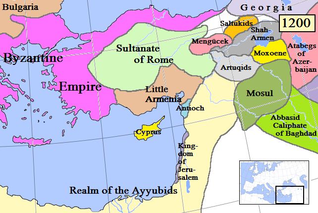
English: Map of Anatolia and some surrounding regions in AD 1200.
(Partially based on Euratlas map of Europe, 1200.) |
| Թուական | |
| Աղբիւր | Սեփական աշխատանք |
| Հեղինակ | Gabagool |
| Այլ մեկնակերպներ |
Derivative works of this file: Kingdom of Cilicia-Anatolia1200-Masry.jpg |
Արտօնագրում
Ես, սույն աշխատանքի հեղինակային իրավունքների տերը, այսուհետ այն հրատարակում եմ հետևյալ արտոնագրի ներքո։
This file is licensed under the Creative Commons Attribution 3.0 Unported license.
- Դուք ազատ էք՝
- կիսել – Աշխատանքը ընդօրինակել, տարածել եւ փոխանցել
- վերափոխել – աշխատանքը յարմարեցնել
- Հետեւեալ պայմաններուն ներքոյ՝
- վերագրում – Աշխատանքը պէտք է վերագրել հեղինակին կամ արտօնատիրոջ պահանջած ձեւով (սակայն ոչ այնպէս մը որ թուայ թէ անոնք կը վաւերացնեն ձեր անոր օգտագործումը)։
Նիշքի պատմութիւն
Սեղմել օրուան/ժամին վրայ նիշքի այդ պահուն ունեցած վիճակը տեսնելու համար
| Օր/Ժամ | Մանրապատկեր | Ծաւալ | Գործածող | Մեկնաբանութիւն | |
|---|---|---|---|---|---|
| ընթացիկ | 15:55, 19 Ապրիլ 2009 | | 642 × 430 (86 ԿԲ) | Gabagool | Added more names to states. Cyprus now yellow to match other maps better. |
| 22:37, 17 Ապրիլ 2009 |  | 642 × 430 (84 ԿԲ) | Gabagool | Extended Shah-Armen area per [http://en.wikipedia.org/wiki/Sassoun] ("The region was later ruled by the Mamikonian dynasty from around 772 until 1189/1190, when the Mamikonians moved to Cilicia after being dispossessed by Shah-Armen.") New Armenia -> Litt | |
| 23:54, 2 Ապրիլ 2009 |  | 642 × 430 (84 ԿԲ) | Gabagool | {{Information |Description={{en|1=Map of Anatolia and some surrounding regions in AD 1200. (Partially based on Euratlas map of Europe, 1200.)}} |Source=Own work by uploader |Author=Gabagool |Date=2009-04-03 |Permission= |other_versions= |
Նիշքի գործածութիւն
Հետեւեալ էջը կը յղուի այս նիշքին՝
Նիշքի համընդհանուր օգտագործում
Հետեւեալ ուիքիները եւս կ'օգտագործեն այս նիշքը՝
- Օգտագործումը ar.wikipedia.org կայքին վրայ
- Օգտագործումը ast.wikipedia.org կայքին վրայ
- Օգտագործումը azb.wikipedia.org կայքին վրայ
- Օգտագործումը az.wikipedia.org կայքին վրայ
- Օգտագործումը be.wikipedia.org կայքին վրայ
- Օգտագործումը de.wikipedia.org կայքին վրայ
- Օգտագործումը el.wikipedia.org կայքին վրայ
- Օգտագործումը en.wikipedia.org կայքին վրայ
- Օգտագործումը eo.wikipedia.org կայքին վրայ
- Օգտագործումը es.wikipedia.org կայքին վրայ
- Օգտագործումը et.wikipedia.org կայքին վրայ
- Օգտագործումը fa.wikipedia.org կայքին վրայ
- Օգտագործումը fr.wikipedia.org կայքին վրայ
- Օգտագործումը gl.wikipedia.org կայքին վրայ
- Օգտագործումը hy.wikipedia.org կայքին վրայ
- Օգտագործումը it.wikipedia.org կայքին վրայ
- Օգտագործումը ja.wikipedia.org կայքին վրայ
- Օգտագործումը ka.wikipedia.org կայքին վրայ
- Օգտագործումը kk.wikipedia.org կայքին վրայ
- Օգտագործումը ko.wikipedia.org կայքին վրայ
- Օգտագործումը lt.wikipedia.org կայքին վրայ
- Օգտագործումը ml.wikipedia.org կայքին վրայ
- Օգտագործումը nl.wikipedia.org կայքին վրայ
- Օգտագործումը no.wikipedia.org կայքին վրայ
- Օգտագործումը pnb.wikipedia.org կայքին վրայ
- Օգտագործումը pt.wikipedia.org կայքին վրայ
- Օգտագործումը ro.wikipedia.org կայքին վրայ
- Օգտագործումը ru.wikipedia.org կայքին վրայ
Տեսնել այս նիշքի աւելի համընդհանուր օգտագործումը: