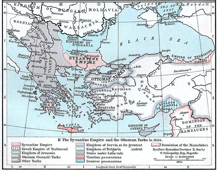
Պատկեր:Byzantine empire 1355.jpg

Կանխաստուգման չափը՝ 758 × 600 կէտիկ։ Այլ չափեր: 304 × 240 կէտիկ | 607 × 480 կէտիկ | 971 × 768 կէտիկ | 1134 × 897 կէտիկ.
Սկզբնական նիշք (1134 × 897 կէտիկներ, նիշքի չափը՝ 380 ԿԲ, MIME-տեսակը՝ image/jpeg)
Նիշքի պատմութիւն
Սեղմել օրուան/ժամին վրայ նիշքի այդ պահուն ունեցած վիճակը տեսնելու համար
| Օր/Ժամ | Մանրապատկեր | Ծաւալ | Գործածող | Մեկնաբանութիւն | |
|---|---|---|---|---|---|
| ընթացիկ | 20:53, 6 Դեկտեմբեր 2022 |  | 1134 × 897 (380 ԿԲ) | Gyalu22 | Artwork |
| 16:44, 29 Մարտ 2018 |  | 1112 × 879 (908 ԿԲ) | Nihil scimus | Few improving (esthetic, contrast, genoese possessions 1355 since Westermann Grosser Atlas zur Weltgeschichte, 1985, ISBN 3-14-100919-8, p. 70, wallachian possessions 1355 under Nicholas Alexander [https://commons.wikimedia.org/wiki/File:Nicolae_Alexandru.jpg] since [https://en.wikipedia.org/wiki/Wallachia#/media/File:Wallachia_13-16c.svg]). | |
| 13:17, 8 Նոյեմբեր 2009 |  | 1134 × 897 (380 ԿԲ) | Alex:D | whitened | |
| 16:00, 3 Դեկտեմբեր 2005 |  | 1134 × 897 (269 ԿԲ) | Migdejong | Map of the Byzantine Empire in the year 1355. Image comes from the University of Texas at Austin: http://geography.about.com/gi/dynamic/offsite.htm?site=http://www.lib.utexas.edu/maps/historical/history%5Feurope.html Map is released into the public |
Նիշքի գործածութիւն
Հետեւեալ էջը կը յղուի այս նիշքին՝
Նիշքի համընդհանուր օգտագործում
Հետեւեալ ուիքիները եւս կ'օգտագործեն այս նիշքը՝
- Օգտագործումը ar.wikipedia.org կայքին վրայ
- Օգտագործումը azb.wikipedia.org կայքին վրայ
- Օգտագործումը az.wikipedia.org կայքին վրայ
- Օգտագործումը ba.wikipedia.org կայքին վրայ
- Օգտագործումը bg.wikipedia.org կայքին վրայ
- Օգտագործումը bs.wikipedia.org կայքին վրայ
- Օգտագործումը ca.wikipedia.org կայքին վրայ
- Օգտագործումը de.wikipedia.org կայքին վրայ
- Byzantinisches Reich
- Makedonien
- 1355
- Großserbien
- Marino Falier
- Andronikos IV.
- Beylik von Aydın
- Eroberung von Philadelphia
- Eroberung von Gallipoli
- Byzantinisch-genuesischer Krieg (1348–1349)
- Byzantinischer Bürgerkrieg (1352–1357)
- Byzantinischer Bürgerkrieg (1373–1381)
- Kreuzzug von Smyrna
- Benutzer:GerardM/Battles including the Ottoman Empire
- Օգտագործումը el.wikipedia.org կայքին վրայ
- Օգտագործումը en.wikipedia.org կայքին վրայ
Տեսնել այս նիշքի աւելի համընդհանուր օգտագործումը:
