Պատկեր:Cyprus 1973 ethnic neutral.svg

Size of this PNG preview of this SVG file: 800 × 570 կէտիկ. Այլ չափեր: 320 × 228 կէտիկ | 640 × 456 կէտիկ | 1024 × 729 կէտիկ | 1280 × 912 կէտիկ | 2560 × 1824 կէտիկ | 1088 × 775 կէտիկ.
Սկզբնական նիշք (SVG նիշք, անուանապէս 1088 × 775 կէտիկ, նիշքի չափը՝ 76 ԿԲ)
Ամփոփում

Սա վեկտոր գրաֆիկական պատկեր է ստեղծված է եղել Inkscape օգնությամբ: .
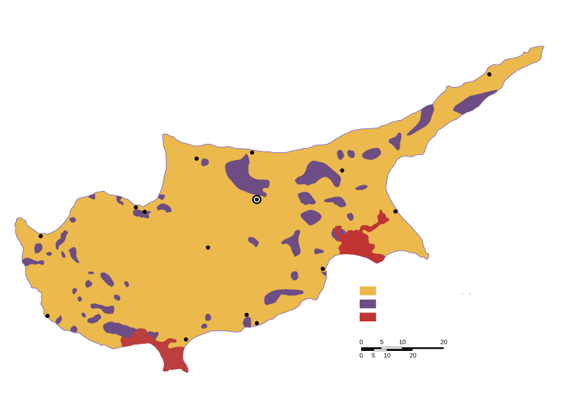
| Նկարագրութիւն | Ethnic distribution svg map of Cyprus in 1973, language neutral (check the source for town names and legend). |
| Թուական | |
| Աղբիւր | Drawn by a map from the "Issues of the Middle East", CIA publication, at the Perry Castaneda colletion, Link: [1]. The yellow colour shows land with predominantly greek-cypriot population, while purple shows predominantly turkish-cypriot population (known in greece as "turkish-cypriot pockets"). British military bases are displayed in red colour. |
| Հեղինակ | Badseed |
| Արտօնութիւն (Նիշքի վերօգտագործում) |
Public Domain |
| Այլ մեկնակերպներ |
|


![[1]](http://www.lib.utexas.edu/maps/europe/cyprus_ethnic_1973.jpg)
Արտօնագրում
| I, the copyright holder of this work, release this work into the public domain. This applies worldwide. In some countries this may not be legally possible; if so: I grant anyone the right to use this work for any purpose, without any conditions, unless such conditions are required by law. |
Նիշքի պատմութիւն
Սեղմել օրուան/ժամին վրայ նիշքի այդ պահուն ունեցած վիճակը տեսնելու համար
| Օր/Ժամ | Մանրապատկեր | Ծաւալ | Գործածող | Մեկնաբանութիւն | |
|---|---|---|---|---|---|
| ընթացիկ | 20:31, 6 Փետրուար 2007 | | 1088 × 775 (76 ԿԲ) | Badseed | {{Information |Description=Ethnic distribution map of Cyprus in 1973. Labels in Greek. |Source=Drawn by a map from the "Issues of the Middle East", CIA publication, at the Perry Castaneda colletion, Link: [http://www.lib.utexas.edu/maps/europe/cyprus_eth |
Նիշքի գործածութիւն
Այս նիշքին յղուող էջեր չկան։
Նիշքի համընդհանուր օգտագործում
Հետեւեալ ուիքիները եւս կ'օգտագործեն այս նիշքը՝
- Օգտագործումը am.wikipedia.org կայքին վրայ
- Օգտագործումը ar.wikipedia.org կայքին վրայ
- Օգտագործումը azb.wikipedia.org կայքին վրայ
- Օգտագործումը az.wikipedia.org կայքին վրայ
- Օգտագործումը be.wikipedia.org կայքին վրայ
- Օգտագործումը bg.wikipedia.org կայքին վրայ
- Օգտագործումը ca.wikipedia.org կայքին վրայ
- Օգտագործումը cs.wikipedia.org կայքին վրայ
- Օգտագործումը en.wikipedia.org կայքին վրայ
- Օգտագործումը eo.wikipedia.org կայքին վրայ
- Օգտագործումը es.wikipedia.org կայքին վրայ
- Օգտագործումը et.wikipedia.org կայքին վրայ
- Օգտագործումը eu.wikipedia.org կայքին վրայ
- Օգտագործումը fa.wikipedia.org կայքին վրայ
- Օգտագործումը fi.wikipedia.org կայքին վրայ
- Օգտագործումը gl.wikipedia.org կայքին վրայ
- Օգտագործումը hu.wikipedia.org կայքին վրայ
- Օգտագործումը id.wikipedia.org կայքին վրայ
- Օգտագործումը it.wikipedia.org կայքին վրայ
- Օգտագործումը ja.wikipedia.org կայքին վրայ
- Օգտագործումը ka.wikipedia.org կայքին վրայ
- Օգտագործումը nl.wikipedia.org կայքին վրայ
- Օգտագործումը no.wikipedia.org կայքին վրայ
- Օգտագործումը pnb.wikipedia.org կայքին վրայ
- Օգտագործումը pt.wikipedia.org կայքին վրայ
- Օգտագործումը ru.wikipedia.org կայքին վրայ
- Օգտագործումը sr.wikipedia.org կայքին վրայ
- Օգտագործումը sv.wikipedia.org կայքին վրայ
- Օգտագործումը th.wikipedia.org կայքին վրայ
- Օգտագործումը tr.wikipedia.org կայքին վրայ
- Օգտագործումը tt.wikipedia.org կայքին վրայ
- Օգտագործումը ur.wikipedia.org կայքին վրայ
- Օգտագործումը uz.wikipedia.org կայքին վրայ
- Օգտագործումը vi.wikipedia.org կայքին վրայ
- Օգտագործումը www.wikidata.org կայքին վրայ
- Օգտագործումը zh.wikipedia.org կայքին վրայ