Պատկեր:Lakes scheme.png
Կանխաստուգման չափը՝ 582 × 600 կէտիկ։ Այլ չափեր: 233 × 240 կէտիկ | 598 × 616 կէտիկ.
Սկզբնական նիշք (598 × 616 կէտիկներ, նիշքի չափը՝ 32 ԿԲ, MIME-տեսակը՝ image/png)

|
This geology image could be re-created using vector graphics as an SVG file. This has several advantages; see Commons:Media for cleanup for more information. If an SVG form of this image is available, please upload it and afterwards replace this template with
{{vector version available|new image name}}.
It is recommended to name the SVG file “Lakes scheme.svg”—then the template Vector version available (or Vva) does not need the new image name parameter. |
Ամփոփում
| Նկարագրութիւն |
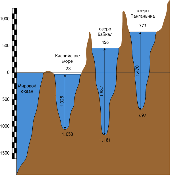
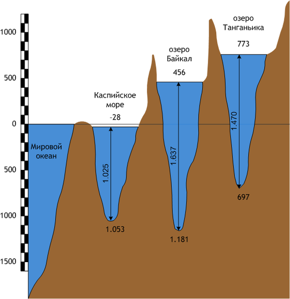
Русский: Сравнительная схема трёх озёр планеты - Каспийского моря, Байкала и Танганьики.
English: Scheme of three lakes of Earth - Caspian sea, Baikal and Tanganyika. |
| Թուական | |
| Աղբիւր | Սեփական աշխատանք |
| Հեղինակ | Afonin |
| Այլ մեկնակերպներ |
Derivative works of this file:
 |
Արտօնագրում
| I, the copyright holder of this work, release this work into the public domain. This applies worldwide. In some countries this may not be legally possible; if so: I grant anyone the right to use this work for any purpose, without any conditions, unless such conditions are required by law. |
Նիշքի պատմութիւն
Սեղմել օրուան/ժամին վրայ նիշքի այդ պահուն ունեցած վիճակը տեսնելու համար
| Օր/Ժամ | Մանրապատկեր | Ծաւալ | Գործածող | Մեկնաբանութիւն | |
|---|---|---|---|---|---|
| ընթացիկ | 19:16, 25 Հոկտեմբեր 2008 | | 598 × 616 (32 ԿԲ) | Afonin~commonswiki | {{Information |Description={{ru|1=Сравнительная схема трёх озёр планеты - Каспийского моря, Байкала и Танганьики.}} {{en|1=Scheme of three lakes of Earth - Caspy sea, Baikal and Tanganjika. |
Նիշքի գործածութիւն
Հետեւեալ էջը կը յղուի այս նիշքին՝
Նիշքի համընդհանուր օգտագործում
Հետեւեալ ուիքիները եւս կ'օգտագործեն այս նիշքը՝
- Օգտագործումը ba.wikipedia.org կայքին վրայ
- Օգտագործումը cv.wikipedia.org կայքին վրայ
- Օգտագործումը hy.wikipedia.org կայքին վրայ
- Օգտագործումը incubator.wikimedia.org կայքին վրայ
- Օգտագործումը rue.wikipedia.org կայքին վրայ
- Օգտագործումը tt.wikipedia.org կայքին վրայ