Պատկեր:Map Europe alliances 1914-en.svg

Size of this PNG preview of this SVG file: 800 × 473 կէտիկ. Այլ չափեր: 320 × 189 կէտիկ | 640 × 379 կէտիկ | 1024 × 606 կէտիկ | 1280 × 758 կէտիկ | 2560 × 1515 կէտիկ | 1002 × 593 կէտիկ.
Սկզբնական նիշք (SVG նիշք, անուանապէս 1002 × 593 կէտիկ, նիշքի չափը՝ 97 ԿԲ)
| Նկարագրութիւն |
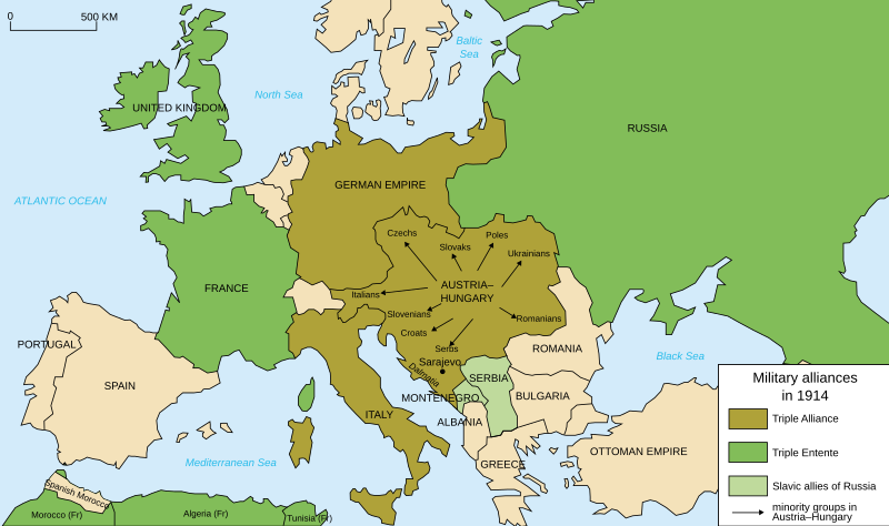
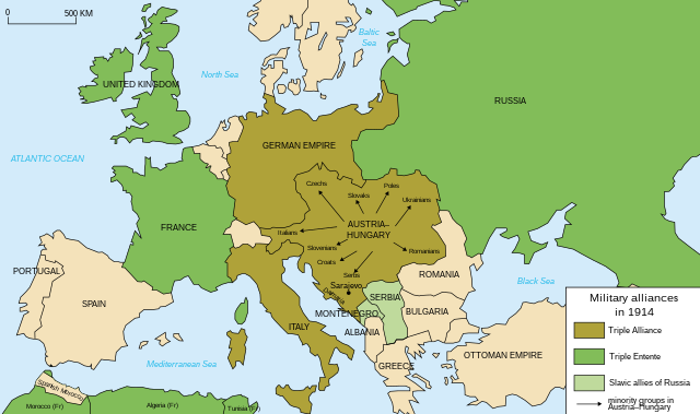
Deutsch: Karte von Militärbündnisse in Europa in 1914, (Englisch) English: Map of military alliances of Europe in 1914. (English) Français : Carte des alliances militaires en Europe en 1914. (Anglais) Русский: Схема военных альянсов в Европе в 1914 г. (англ.) |
| Թուական |
|
| Աղբիւր | Translated in English from French SVG Map_Europe_alliances_1914-fr.svg |
| Հեղինակ |
|
| Այլ մեկնակերպներ |
Derivative works of this file: Map Europe alliances 1914-he.svg
[] .gif)
|


W3C-validity not checked.

|
This SVG file contains embedded text that can be translated into your language, using any capable SVG editor, text editor or the SVG Translate tool. For more information see: About translating SVG files. |
| Սա խմբագրված պատկեր է, որը համեմատ բնօրինակին ենթարկվել է թվային մշակման։ Փոփոխությունները՝ English translation: Սկզբնական պատկերը գտնվում է այստեղ՝ Map Europe alliances 1914-fr.svg։ Խմբագրել է Fluteflute մասնակիցը։
|
Ես, սույն աշխատանքի հեղինակային իրավունքների տերը, այսուհետ այն հրատարակում եմ հետևյալ արտոնագրի ներքո։
This file is licensed under the Creative Commons Attribution-Share Alike 2.5 Generic, 2.0 Generic and 1.0 Generic license.
- Դուք ազատ էք՝
- կիսել – Աշխատանքը ընդօրինակել, տարածել եւ փոխանցել
- վերափոխել – աշխատանքը յարմարեցնել
- Հետեւեալ պայմաններուն ներքոյ՝
- վերագրում – Աշխատանքը պէտք է վերագրել հեղինակին կամ արտօնատիրոջ պահանջած ձեւով (սակայն ոչ այնպէս մը որ թուայ թէ անոնք կը վաւերացնեն ձեր անոր օգտագործումը)։
- Նոյնապայման տարածում – Եթէ այս աշխատանքը ձեւափոխէք, փոխակերպէք կամ անոր հիման վրայ ստեղծէք ձերը, ապա կրնաք զայն տարածել միայն նոյնպիսի կամ համարժէք արտօնագրով։
Original upload log
This image is a derivative work of the following images:
- File:Map_Europe_alliances_1914-fr.svg licensed with Cc-by-sa-2.5,2.0,1.0, Cc-by-sa-2.5,2.0,1.0/en
- 2007-02-26T23:36:35Z Bibi Saint-Pol 998x593 (100171 Bytes) {{Information |Description= {{fr|Carte des alliances militaires en Europe en 1914.}} |Source=Création personnelle(version renommée de [[:Image:Les rivalités en Europe en 1914.svg]]) |Date=2006-10-31 |Author=[[User:Histori
Uploaded with derivativeFX
Նիշքի պատմութիւն
Սեղմել օրուան/ժամին վրայ նիշքի այդ պահուն ունեցած վիճակը տեսնելու համար
| Օր/Ժամ | Մանրապատկեր | Ծաւալ | Գործածող | Մեկնաբանութիւն | |
|---|---|---|---|---|---|
| ընթացիկ | 20:59, 4 Ապրիլ 2021 | | 1002 × 593 (97 ԿԲ) | Andrewtips | File uploaded using svgtranslate tool (https://svgtranslate.toolforge.org/). Added translation for zh-hant. |
| 21:02, 4 Օգոստոս 2020 |  | 1002 × 593 (92 ԿԲ) | Ionaki | File uploaded using svgtranslate tool (https://svgtranslate.toolforge.org/). Added translation for eu. | |
| 21:02, 4 Օգոստոս 2020 |  | 1002 × 593 (92 ԿԲ) | Ionaki | File uploaded using svgtranslate tool (https://svgtranslate.toolforge.org/). Added translation for eu. | |
| 20:59, 4 Օգոստոս 2020 |  | 1002 × 593 (92 ԿԲ) | Ionaki | File uploaded using svgtranslate tool (https://svgtranslate.toolforge.org/). Added translation for eu. | |
| 15:14, 2 Օգոստոս 2020 |  | 1002 × 593 (72 ԿԲ) | Bogomolov.PL | reservoirs on Dnieper, Don and Volga rivers were built after Second WW, erased. Romania, Serbia, Montenegro, Albania and Bulgaria borders corrected | |
| 11:22, 21 Յունուար 2017 |  | 1002 × 593 (75 ԿԲ) | Perey | This portrays the Triple Alliance, not the Central Powers (of which Italy was never one). Error introduced in version dated 2010-03-07 by Mnmazur (talk). | |
| 21:18, 28 Նոյեմբեր 2015 |  | 1002 × 593 (75 ԿԲ) | Turnless | Aland Islands | |
| 12:25, 2 Յունուար 2015 |  | 1002 × 593 (75 ԿԲ) | Borodun | Moonsund archipelago is territory of Russia | |
| 00:30, 2 Յունուար 2015 |  | 1002 × 593 (70 ԿԲ) | ZYjacklin | Capitalize the name for Romania. | |
| 16:49, 17 Նոյեմբեր 2010 |  | 1002 × 593 (70 ԿԲ) | Ras67 | "cropped" and minor things |
Նիշքի գործածութիւն
Այս նիշքին յղուող էջեր չկան։
Նիշքի համընդհանուր օգտագործում
Հետեւեալ ուիքիները եւս կ'օգտագործեն այս նիշքը՝
- Օգտագործումը ar.wikipedia.org կայքին վրայ
- Օգտագործումը bcl.wikipedia.org կայքին վրայ
- Օգտագործումը bh.wikipedia.org կայքին վրայ
- Օգտագործումը br.wikipedia.org կայքին վրայ
- Օգտագործումը cy.wikipedia.org կայքին վրայ
- Օգտագործումը da.wikipedia.org կայքին վրայ
- Օգտագործումը el.wikipedia.org կայքին վրայ
- Օգտագործումը en.wikipedia.org կայքին վրայ
- Franz Joseph I of Austria
- Triple Alliance (1882)
- Military alliance
- Triple Entente
- Yugoslav Committee
- Treaty of London (1915)
- Switzerland during the World Wars
- Polish Legions in World War I
- Two-front war
- History of Western civilization
- World War I
- France–Russia relations
- 1914
- European balance of power
- Wikipedia:Graphics Lab/Illustration workshop/Archive/Nov 2010
- Sweden during World War I
- Talk:World War I/Archive 16
- User:Chickstarr404/Gather lists/16060 – "Paris 1919" by Margaret Macmillan
- User:Chickstarr404/Gather lists
- User:Falcaorib
- Friedrich von Pourtalès
- Draft:Participants of World War I
- Օգտագործումը en.wikibooks.org կայքին վրայ
- Օգտագործումը en.wiktionary.org կայքին վրայ
- Օգտագործումը et.wikipedia.org կայքին վրայ
- Օգտագործումը eu.wikipedia.org կայքին վրայ
- Օգտագործումը fa.wikipedia.org կայքին վրայ
- Օգտագործումը fiu-vro.wikipedia.org կայքին վրայ
- Օգտագործումը fi.wikipedia.org կայքին վրայ
- Օգտագործումը fi.wikibooks.org կայքին վրայ
- Օգտագործումը fo.wikipedia.org կայքին վրայ
- Օգտագործումը fy.wikipedia.org կայքին վրայ
Տեսնել այս նիշքի աւելի համընդհանուր օգտագործումը: